

Courses
In addition to the free webinars in which you can watch Hans and Kurt work their magic, the presenters have developed on-demand online courses that interactively step you through each of the elements covered in the webinars, culminating in some awesome maps.
Here is the final map that you will create during the QGIS for Surface Water course, which includes all of the terrain processing tools to determine Strahler stream orders, flow paths, catchment boundaries, and more:
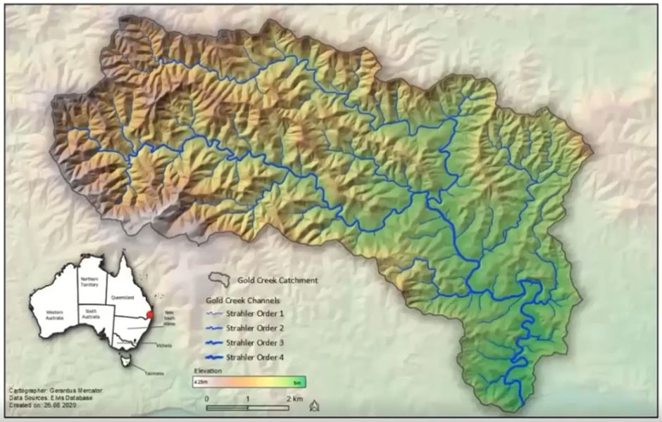
This is the same catchment that we use for tutorial models in our HEC-HMS and HEC-RAS courses.
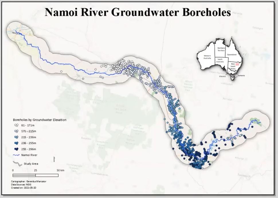
And here is the final map from the QGIS for Groundwater course, which includes all of the data wrangling to import, sort, and statistically analyse the well/bore data:
Book
Here’s the final map that you will create by following the steps in the book QGIS for Hydrological Applications:

Purchase the printed book through Amazon or the electronic book through Locate Press:
We highly recommend this book along with all of the accompanying webinars and tutorials that Hans and Kurt have produced.
- Check out Qwast GIS, the website for Hans’ consulting business
- Kurt is currently engaged with Septima GIS
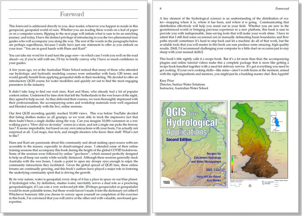
Here’s the text of the Foreword from the Second Edition:
Foreword
This foreword is addressed directly to you, dear reader, wherever you happen to reside in this geospecial, geospatial world of ours. Whether you are reading these words on a leaf of paper or on a computer screen, flipping to the next page will initiate what is sure to be an enriching journey; and today, I have the distinct privilege of introducing to you the two phenomenal tour guides who will accompany you along the way. The rest of the words in the paragraphs below are perhaps superfluous, because I really have just one statement to offer as you embark on your tour: “You are in good hands with Hans and Kurt!”
You can take my word for it and turn the page now – in which case I wish you well on the road ahead – or, if you’re still with me, I’ll try to briefly convey why I have so much confidence in your guides.
A few years ago, we at the Australian Water School noticed that many of those who attended our hydrologic and hydraulic modelling courses were unfamiliar with basic GIS terms and would greatly benefit from applying geospatial skills in their modelling. We decided to offer an introductory QGIS course for water modellers and quickly set out to find the most engaging presenters in the industry.
It didn’t take long to find our rock stars, Kurt and Hans, who already had a lot of popular content online. Undeterred by time slots that left the Netherlands in the wee hours of the night, they agreed to help us out. As they delivered their courses, we were thoroughly impressed with their professionalism; the accompanying notes and workshop materials were well organised and blended seamlessly with the live, online sessions.
Our first QGIS recording quickly reached 10,000 views. This was before YouTube decided that listing dislikes makes us all grumpy, so we were able to track the impressive fact that there hadn’t been a single dislike along the way. Can you imagine 10,000 customers in a row walking past a “How did we do today” screen in a store, and not a single one picks the frowny face? It seems improbable, but based on my own interactions with your hosts, I’m actually not surprised at all. Cool maps, free tech, and straight shooters who know their stuff: What’s not to like?
Hans and Kurt are passionate about this community and about making open-source software accessible to the masses, especially in disadvantaged areas. I attended some of their online training sessions that accompany this book during the height of the global COVID lockdowns; some of the sessions were followed by online “geo-beers”, which seemed perfectly designed to help us all keep our sanity while socially distanced. Although these sessions generally stuck Australia with the wee hours, I made a point to open my droopy eyes enough to enjoy the community interactions they facilitated. Given the global spread of QGIS fans, these online forums are continually growing, and this book’s authors have played a major role in fostering the underlying community spirit that is driving the growth.
By its very nature, water is geospatial; every drop of it has a place in space on our blue planet. A hydrologist who, by definition, studies water, inevitably serves a dual role as a practicing geospatialologist, if I can coin a very awkward job title. [Perhaps geospecialist or geospatialist would be more palatable terms, but those words haven’t made it into the dictionary yet either!] Whichever honorary title you choose to convey upon yourself on completion of the exercises in this book, I’m convinced that you will arrive at the other end with valuable, newfound geo-expertise.
A key element of the hydrological sciences is an understanding of the distribution of water: mapping where it is, where it has been, and where it is going. Communicating that distribution effectively will help you stand out in your field. Whether you are new to the georeferenced world or bringing previous experience to a new platform, this book is sure to provide you with indispensable, time-saving tools that will make your work shine. I have to admit that I still find some occasional zen in manually delineating basin boundaries and flow paths myself; sometimes it’s hard to step back and let a machine do all of that work, but the available tools that you will master in this book can sure produce some amazing, high-quality results. [Still, I’d recommend challenging your computer to a little duel on occasion just to stay sharp with your manual skills!]
This book’s title rightly calls it a recipe book. But it’s a lot more than that; the accompanying plugins and online tutorial videos make this a complete package that is more like getting a recipe book bundled together with a meal-kit delivery service. It’s got everything you need to get cooking. If your own cooking skills – like mine – aren’t worth beans at the moment, armed with the right ingredients and mentors, you might just be a budding master chef. Bon Appétit!
Krey Price
Director, Surface Water Solutions
Instructor, Australian Water School
Contact us with any queries